|
|
Broad Ripple Random Ripplings


The news from Broad Ripple
Brought to you by The Broad Ripple Gazette
(Delivering the news since 2004, every two weeks)

|
| Brought to you by: |

|

|

|

|

|

|
Converted from paper version of the Broad Ripple Gazette (v15n03)
Everything you always wanted to know about the canal...part seventeen - Downtown Canal part 2
posted: Feb. 02, 2018
The Downtown Canal (part 2)
The Broad Ripple Gazette presented (in various issues from Volume 12 #18 through Volume 13 #9) the history and workings of the Indiana Central Canal as it exists today, from the canal's creation at the dam on the White River in Broad Ripple, down to the Citizens White River Treatment Plant near the Fall Creek and 16th Street.
A portion of the original downtown canal map (published in Volume 14 Number 5 of the Gazette) showing the original canal bed in blue, the current canal in red and the current water sources in green.
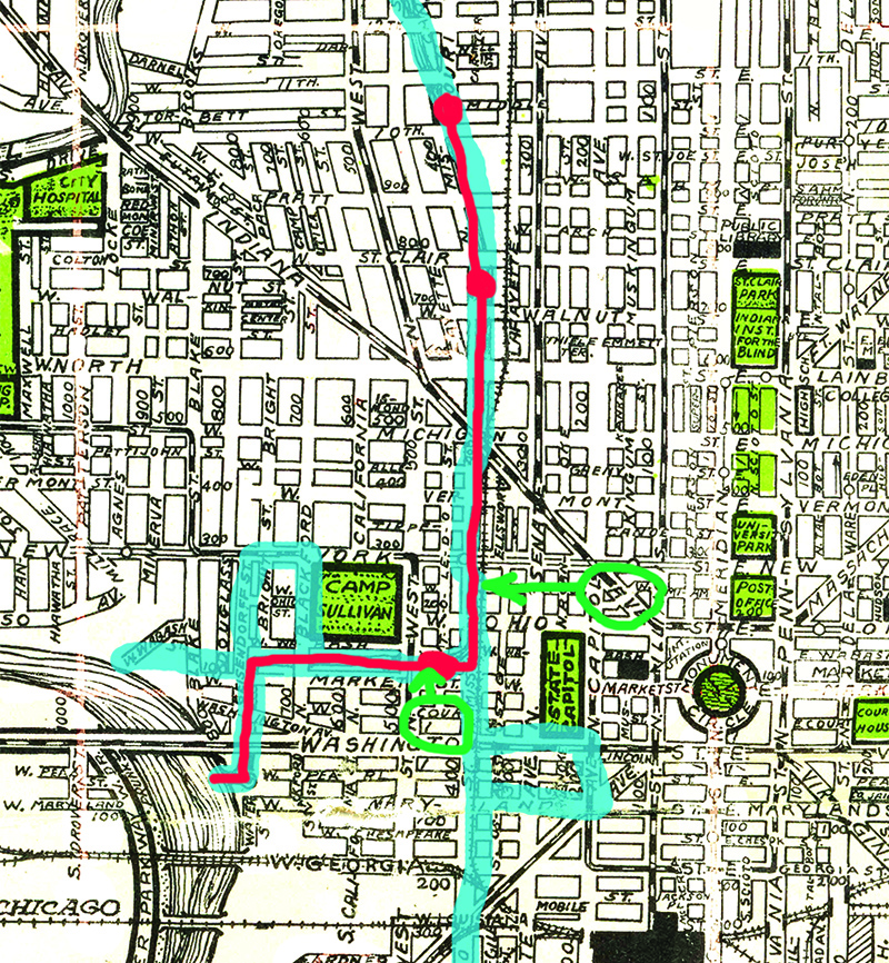
This article is the second part that covers the portion of the canal that was past the water treatment plant. It currently runs from 11th Street, through downtown and White River State Park, spilling over into the White River near the southwest corner of the NCAA Hall of Champions.
From issue #5 to start this installment:
I had always believed that when the interstate was built downtown, the construction cut off the canal path. I had been told that the canal was piped underground at this point and then it re-emerged at 11th Street and flowed on the rest of the way to the White River in White River State Park. I thought the only changes were the construction of a concrete basin to replace the original earthen structure dug in the 1800s. I was wrong. During my interview with Citizens Energy, the owners of the active canal from Broad Ripple to the White River Treatment Plant, I learned that the canal, in fact, ends at the treatment plant, with all its 8-million gallons a day emptying into the facility, to be treated and delivered to the water users in the city. The real story of the water in the downtown canal was a more complicated one and I would find those details at the Department of Metropolitan Development.
In 2016, I met with John Bartholomew, Public Information Officer for City of Indianapolis, Department of Metropolitan Development and Steve Schulmeyer, Project manager at City of Indianapolis, Department of Metropolitan Development, at their City-County Building office to discuss the history of the downtown Canal Walk project.
Over the decades, the canal south of the White River Treatment Plant was mostly unused, except as a source of water power until 1969 for the Indianapolis Water Company's (IWC) West Washington Pumping Station (now a preserved historic building in White River State Park).
According to Now That Time Has Had Its Say [J. Darrell Bakken, 2002], the IWC sent a letter to the state highway commission in 1965 "informing it of the company's intent to abandon the lower canal by early 1969". This would make available the land needed to build a four-sided interstate loop with west and east legs. Negotiations fell through and the interstate was designed to only go around the east side of downtown, resulting in the current north-south split mess that Indy is still trying to remedy. In 1969 the State of Indiana only purchased two small pieces of the canal right-of-way for the Interstate 65 project, one near 36th Street for a canal/White River bridge, and the other for the exits around 12th Street.
Before the Interstate was built in the early 1970s, the canal was moved underground to a pipe to carry the water (what was left after the roughly 8,000,000 gallons a day had been fed into the water treatment plant) from about 14th Street to 11th Street, where the canal picked up again. There was not much water in the downtown canal. It became a collector of trash and bottles. There was an idea to fix the poor condition of the canal to turn it into an asset.
In 1972, a trust was established for the purpose of transferring ownership of the downtown portion of the Central Canal (starting at about 21st Street) from the IWC to the City of Indianapolis. The other portion of the canal (from the dam in Broad Ripple that creates the flow for the canal, down to the present-day end at the White River Treatment Plant at 16th Street), remains in the possession of Citizens Energy for use as the main conduit of water for the north side of Indianapolis. This 1972 agreement stated that the canal would be used to the benefit of the City of Indianapolis "for park and recreational purposes." Another agreement stated that the City had until 1977 to act on the renovation of the downtown canal.
The "twenty-two-person Waterways Task Force was created by the Greater Indianapolis Progress Committee" [Bakken, J. Darrell. Now That Time Has Had Its Say. 1st Books. 2002] was formed to study the project, thanks to a Lilly Endowment grant. The 1974 report was largely dismissed due to "high excavation, reconstruction, and redevelopment costs and because it threated to damage historic Military Park." The Historic Landmarks Foundation of Indiana (HLFI) prepared a report in 1975 stating that canal redevelopments in other cities had positive economic impacts. The report called for the "development of the Lower Central Canal as an urban linear park". It would later be called Canal Walk.
In 1975, the Department of Metropolitan Development Historic Preservation Division proposed plans from New York Street to the White River (this is approximately the lower third of today's downtown canal).
In 1976 the IWC deeded the downtown portion of the canal to the City of Indianapolis. This was a 2.25 mile stretch.
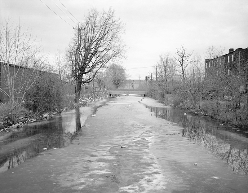
A view of the canal looking north from North Street, from a report by the Department of the Interior 1985.
In 1986 the construction began with funding from the Urban Mass Transit Administration, Indianapolis Department of Transportation, the State Office Building Commission, the Lilly Endowment, and the Indianapolis Foundation. [Bakken, J. Darrell. Now That Time Has Had Its Say. 1st Books. 2002]
The existing canal was drained south of Interstate 65. The canal bed was lowered 12 feet and the canal channel was lined with concrete to a uniform width of 50 feet. The exceptions were for basins at Ohio, New York, Walnut and 11th Streets. Pedestrian walkways were to be added to both sides.
This first project, running from 1985 through 1991, cost $14,400,000. This seven-block section included the portion of the canal that ran from West Street, south of Ohio Street, north to St. Clair Street.
alan@broadripplegazette.com
|
|
|
|
| Brought to you by: |

|
|
|
| Brought to you by: |
|
|

|
|
|
||||
|
Copyrighted Property Of Broad Ripple Publishing
Site terms Broad Ripple Random Ripplings is hosted at Ionos.com |
||||

